Skip to content

Bonita Springs,through time.

5 eras · 1513–2026 · every fact sourced · compiled from the sources shown, not yet reviewed by a historian

Populationfrom 1990

—

Calusa homeland and Spanish contact

1513–1869: Calusa homeland and Spanish contact

Era 1 · 1513–1869

Calusa homeland and Spanish contact

Archaeology places people here about 8,000 years ago, and when Ponce de Leon met the Calusa in 1513 the area was home to thousands. Within a couple of centuries European diseases and slave trading had decimated the Calusa chiefdom.

Image shown for this era: 1859 U.S. Coast Survey triangulation chart of the Florida peninsula, with the Gulf coast running south past Charlotte Harbor toward Key West.. 1859 · U.S. Coast Survey, Report of the Superintendent (1859); scan by Geographicus Rare Antique Maps, via Wikimedia Commons · Public domain · Source

Sources
  1. History, City of Bonita Springs (accessed 2026-11-09)
  2. History, City of Bonita Springs (accessed 2026-11-09)
Correct this era: Calusa homeland and Spanish contact

Era 2 · 1870–1920

Survey: homesteaders on Surveyor's Creek

After the 1870s survey camp, Survey grew from scattered homesteads into a village, with a post office in 1901 and the two-story Eagle Hotel serving hunters and anglers by 1910. Developers later renamed the town Bonita Springs and Surveyor's Creek the Imperial River; until 1917 the only way in was by boat.

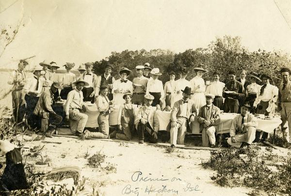
Image shown for this era: About thirty men and women in hats and white summer clothes posed around picnic tables among dune scrub on Big Hickory Island, April 1908.. 1908 · State Archives of Florida, Florida Memory (Koreshan Unity Collection), via Wikimedia Commons · Public domain · Source

Key moments

  1. Surveyors camp on the upper Imperial River and the place becomes "Survey"

    In the 1870s Army Corps of Engineers surveyors mapping remote Southwest Florida camped on the upper Imperial River. After they left, the area, and later the community, was recorded on maps as "Survey", and the river as "Surveyor's Creek".

    Source

    1. History, City of Bonita Springs (accessed 2026-11-09)
  2. Survey gets a post office

    A post office opened in the village of Survey, the community's name before it became Bonita Springs.

    Source

    1. History, City of Bonita Springs (accessed 2026-11-09)
  3. The Eagle Hotel opens to sportsmen

    By 1910 the two-story Eagle Hotel was catering to visitors drawn by the area's hunting and fishing.

    Source

    1. History, City of Bonita Springs (accessed 2026-11-09)
1 more from this era
  1. First road to Fort Myers

    Until a road to Fort Myers was completed in 1917, Bonita Springs could only be reached by boat.

    Source

    1. Bonita Springs, Florida, Advisory Council on Historic Preservation (accessed 2026-11-09)

Sources

  1. History, City of Bonita Springs (accessed 2026-11-09)
  2. History, City of Bonita Springs (accessed 2026-11-09)
  3. Bonita Springs, Florida, Advisory Council on Historic Preservation (accessed 2026-11-09)
Correct this era: Survey: homesteaders on Surveyor's Creek

Era 3 · 1921–1979

Railroad, Tamiami Trail and roadside attractions

In the early 1920s Barron Collier extended his Fort Myers-Southern Railroad to Bonita Springs, and with the Tamiami Trail completed in 1928 a land boom followed, during which the town was briefly incorporated. From 1936 roadside attractions such as the Everglades Reptile (later Wonder) Gardens, the Shell Factory and a Seminole village drew travellers, but Bonita Springs stayed a quiet small town for decades.

Image shown for this era: 1958 USGS topographic map of the Bonita Springs area showing the town along the Imperial River, the Tamiami Trail and railroad, Bonita Beach and Estero Bay, and the Gulf of Mexico.. 1958 · U.S. Geological Survey, Bonita Springs, Fla. 7.5-minute quadrangle (1958), via Wikimedia Commons · Public domain · Source

Key moments

  1. Bonita Springs Elementary School built

    The 1921 Bonita Springs elementary school is one of the historic sites on the historical society's walking tours.

    Source

    1. Bonita Springs, Florida, Advisory Council on Historic Preservation (accessed 2026-11-09)
  2. Tamiami Trail completed

    The completion of the Tamiami Trail, together with the railroad extension, brought another land boom to Bonita Springs.

    Source

    1. History, City of Bonita Springs (accessed 2026-11-09)
  3. Everglades Reptile Gardens opens

    The first major tourist attraction, the Everglades Reptile Gardens, opened in 1936 and helped put Bonita Springs on the map; it survives as the Everglades Wonder Gardens.

    Source

    1. History, City of Bonita Springs (accessed 2026-11-09)
2 more from this era
  1. The Shell Factory burns and moves away

    The Shell Factory, built on Terry Street in the late 1930s for the tourist trade, burned in 1952 and moved to North Fort Myers.

    Source

    1. History of Bonita Springs, Fort Myers Beach Observer (accessed 2026-11-09)
  2. Greyhound track opens

    The Naples-Fort Myers Greyhound Track opened in Bonita Springs.

    Source

    1. History, City of Bonita Springs (accessed 2026-11-09)

Sources

  1. History, City of Bonita Springs (accessed 2026-11-09)
  2. History, City of Bonita Springs (accessed 2026-11-09)
  3. History, City of Bonita Springs (accessed 2026-11-09)
  4. Bonita Springs, Florida, Advisory Council on Historic Preservation (accessed 2026-11-09)
  5. History, City of Bonita Springs (accessed 2026-11-09)
Correct this era: Railroad, Tamiami Trail and roadside attractions

Era 4 · 1980–1998

Interstate-era growth

Air conditioning, Interstate 75, a nearby major airport and the new US 41 bypass brought fast population growth in the 1980s and 1990s, with shopping malls, offices and golf courses.

Image shown for this era: USGS topographic map of Bonita Springs photorevised in 1987, with the growth since 1958, including Interstate 75, shown in purple.. 1987 · U.S. Geological Survey, Bonita Springs, Fla. 7.5-minute quadrangle (1958, photorevised 1987), via Wikimedia Commons · Public domain · Source

Sources

  1. History, City of Bonita Springs (accessed 2026-11-09)
Correct this era: Interstate-era growth

Era 5 · 1999–2026

City of Bonita Springs

Residents voted to incorporate a second time, and the city was incorporated on December 31, 1999. The city has since adopted a historic preservation ordinance and restored the Liles Hotel, while hurricanes Irma (2017) and Ian (2022) flooded neighbourhoods along the Imperial River and the coast.

Image shown for this era: Pink brick one-story school building with "1921 Bonita Springs School" on its parapet and a historical marker out front, under a blue sky.. 2010 · Ebyabe, CC BY-SA 3.0, via Wikimedia Commons · CC BY-SA · Source

Key moments

  1. Bonita Springs incorporates for the second time

    After a vote of residents, Bonita Springs became a city again on December 31, 1999, decades after a short-lived first incorporation.

    Source

    1. 25th Anniversary, City of Bonita Springs (accessed 2026-11-09)
  2. City restores the 1926 Liles Hotel

    The city renovated the 1926 Liles Hotel on the Imperial River; it now houses city offices and the historical society's resource center and exhibits.

    Source

    1. Bonita Springs, Florida, Advisory Council on Historic Preservation (accessed 2026-11-09)
  3. Named a Preserve America Community

    Bonita Springs was designated a Preserve America Community for its historic preservation work.

    Source

    1. Bonita Springs, Florida, Advisory Council on Historic Preservation (accessed 2026-11-09)
4 more from this era
  1. Hurricane Irma floods the city

    Hurricane Irma caused flooding throughout Bonita Springs, which was identified as the third most impacted community in Florida.

    Source

    1. Voluntary Home Buyout Program, City of Bonita Springs (accessed 2026-11-09)
  2. Flood-prone homes offered a voluntary buyout

    The city announced a Hurricane Irma voluntary home buyout program focused on the flood-prone Quinn/Downs area south of the Imperial River.

    Source

    1. City of Bonita Springs announces Hurricane Irma voluntary home buyout program, City of Bonita Springs (accessed 2026-11-09)
  3. Hurricane Ian's storm surge

    Hurricane Ian's storm surge reached 8 to 12 feet above ground level in Bonita Beach and Bonita Springs.

    Source

    1. Tropical Cyclone Report: Hurricane Ian (AL092022), NOAA National Hurricane Center (accessed 2026-11-09)
  4. Everglades Wonder Gardens turns 90

    The Everglades Wonder Gardens, opened in 1936 on the Imperial River along the old Tamiami Trail, celebrated its 90th year.

    Source

    1. The Wonder Gardens in Bonita Springs celebrates 90 years, WGCU News (accessed 2026-11-09)

Sources

  1. 25th Anniversary, City of Bonita Springs (accessed 2026-11-09)
  2. Bonita Springs, Florida, Advisory Council on Historic Preservation (accessed 2026-11-09)
Correct this era: City of Bonita Springs

Then & Now

Bonita Springs, 1870 to 2026

Surveyors camp on the upper Imperial River and the place becomes "Survey" · drag to compare

1859 U.S. Coast Survey triangulation chart of the Florida peninsula, with the Gulf coast running south past Charlotte Harbor toward Key West.
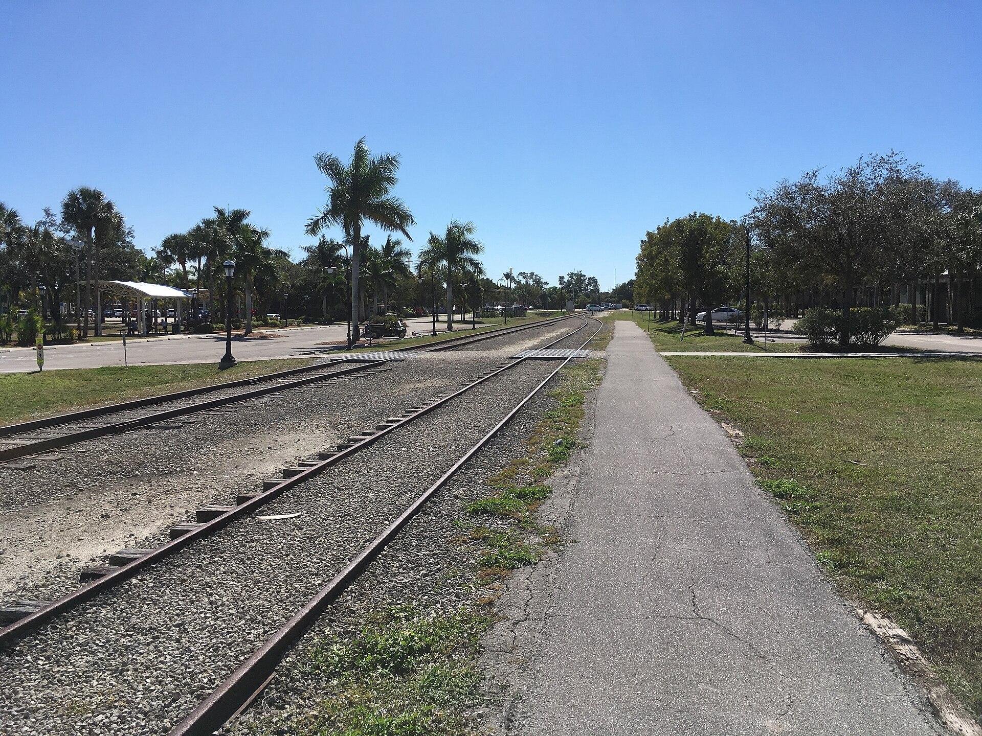
Railroad tracks running straight through downtown Bonita Springs beside the old passenger platform, lined with palms under a clear blue sky.
18702026

Then image1859 · U.S. Coast Survey, Report of the Superintendent (1859); scan by Geographicus Rare Antique Maps, via Wikimedia Commons · Public domain · Source

Now image2019 · Sanibel sun, CC BY-SA 4.0, via Wikimedia Commons · CC BY-SA · Source

Help us get it right

History is never finished.

This timeline is compiled from the public records cited on each era and event. Every quote is checked against its source automatically, and items marked Reviewed have also been checked by a person. Images are public domain or openly licensed, each with its credit. If you know something we’ve missed or got wrong, or you hold records of your own, we’d like to hear from you.

See what’s happening in Bonita Springs today →