Skip to content

North Fort Myers,through time.

5 eras · 1872–2026 · every fact sourced · compiled from the sources shown, not yet reviewed by a historian

Populationfrom 1990

—

New Prospect and the north shore

1872–1925: New Prospect and the north shore

Era 1 · 1872–1925

New Prospect and the north shore

Small settlements such as New Prospect, Samville, Bayshore, Slater and Woodrow grew up north of the Caloosahatchee. New Prospect had a cemetery and a one-room school by 1884, but settlement stayed sparse until the land boom of the mid-1920s.

Key moments

  1. Settlers found New Prospect

    New Prospect, the oldest of the communities that now make up North Fort Myers, was founded when a group of settlers planted orange groves on the north side of the Caloosahatchee.

    Source

    1. National Register of Historic Places nomination: English, J. Colin, School, National Park Service (accessed 2026-11-09)
  2. New Prospect's first school and cemetery

    New Prospect established a cemetery and built its first school, a small wood-frame building.

    Source

    1. National Register of Historic Places nomination: English, J. Colin, School, National Park Service (accessed 2026-11-09)
  3. First subdivision platted

    The first subdivision in the New Prospect area was platted.

    Source

    1. National Register of Historic Places nomination: English, J. Colin, School, National Park Service (accessed 2026-11-09)

Sources

  1. National Register of Historic Places nomination: English, J. Colin, School, National Park Service (accessed 2026-11-09)
  2. North Fort Myers history, North Fort Myers Neighbor (accessed 2026-11-09)
Correct this era: New Prospect and the north shore

Era 2 · 1926–1945

Boom subdivisions, a school and a bridge

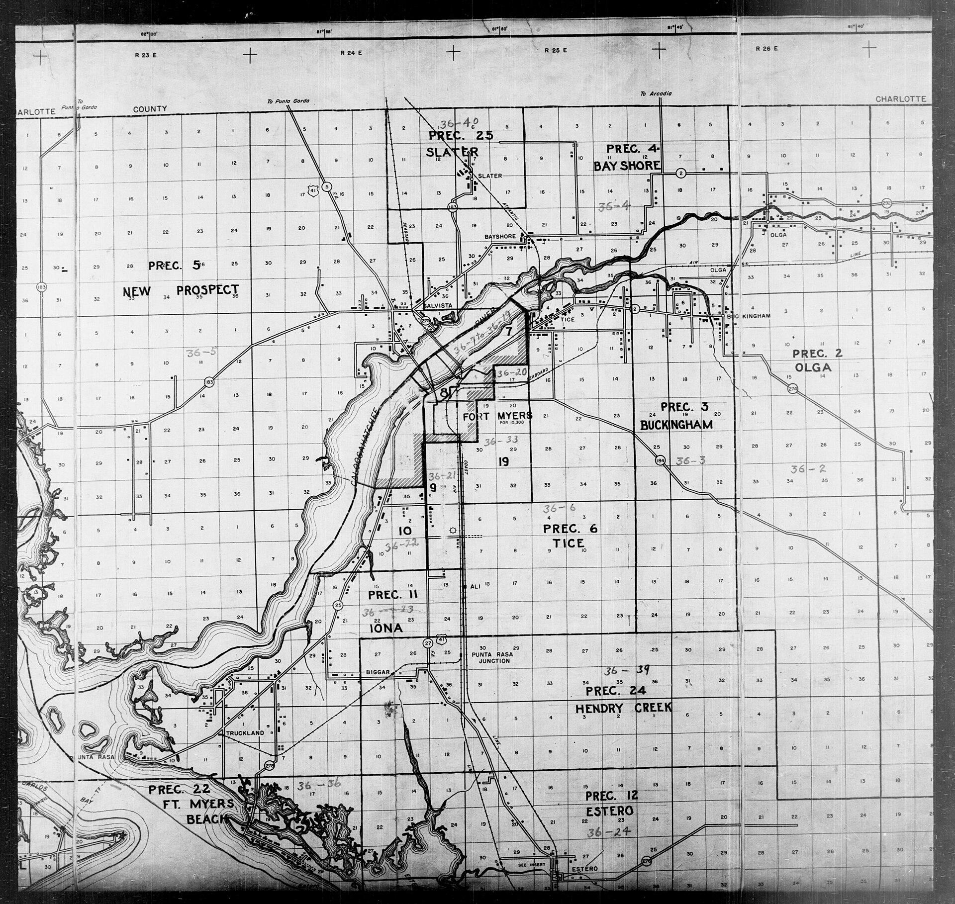
Palmona Park and Tamiami Estates were platted in 1926, and the growing population got a new school in 1928-29. The Edison Bridge opened in 1931, and the community began to develop in the years after it was finished.

Image shown for this era: 1940 census map of central Lee County showing the north shore of the Caloosahatchee opposite Fort Myers, with the New Prospect, Slater and Bay Shore precincts, the settlements of Salvista, Bayshore and Slater, and US 41 running north toward Punta Gorda.. 1940 · U.S. Census Bureau, 1940 Census Enumeration District Maps, Lee County (National Archives 5829693), via Wikimedia Commons · Public domain · Source

Key moments

  1. Palmona Park and Tamiami Estates platted

    During the Florida land boom two large residential subdivisions were platted, and Palmona Park's growth quickly raised the area's population.

    Source

    1. National Register of Historic Places nomination: English, J. Colin, School, National Park Service (accessed 2026-11-09)
  2. Work begins on the New Prospect School

    After residents petitioned the school board, construction of a new Mediterranean Revival school began on Pine Island Road; it later took the name J. Colin English School.

    Source

    1. National Register of Historic Places nomination: English, J. Colin, School, National Park Service (accessed 2026-11-09)
  3. New school opens

    The eight-classroom school with an auditorium was finished in time for the 1929 school year.

    Source

    1. National Register of Historic Places nomination: English, J. Colin, School, National Park Service (accessed 2026-11-09)
1 more from this era
  1. Edison Bridge opens

    A new bridge over the Caloosahatchee, named for Thomas Edison, opened on his birthday; North Fort Myers began to develop in the years after it was completed.

    Source

    1. Bridging the past and the future of Fort Myers, Edison and Ford Winter Estates (accessed 2026-11-09)

Sources

  1. National Register of Historic Places nomination: English, J. Colin, School, National Park Service (accessed 2026-11-09)
  2. North Fort Myers history, North Fort Myers Neighbor (accessed 2026-11-09)
Correct this era: Boom subdivisions, a school and a bridge

Era 3 · 1946–1969

Roadside Florida and postwar growth

The Shell Factory moved to North Fort Myers in 1954 after a fire in Bonita Springs, and survived Hurricane Donna's damage in 1960. The community's growth took off in the 1960s.

Image shown for this era: 1958 USGS topographic map with North Fort Myers labeled on the north bank of the Caloosahatchee River, its streets and canals clustered along US 41, the English school, and open land and flowing wells to the west.. 1958 · U.S. Geological Survey, Fort Myers NW, Fla. 7.5-minute quadrangle (1958), via Wikimedia Commons · Public domain · Source

Key moments

  1. The Shell Factory moves to North Fort Myers

    After a fire destroyed its Bonita Springs building, the Shell Factory roadside attraction moved to North Fort Myers.

    Source

    1. Shell Factory: NFM success story, North Fort Myers Neighbor (accessed 2026-11-09)
  2. Hurricane Donna wrecks the Shell Factory store

    Hurricane Donna destroyed the Shell Factory's retail store.

    Source

    1. Shell Factory: NFM success story, North Fort Myers Neighbor (accessed 2026-11-09)

Sources

  1. Shell Factory: NFM success story, North Fort Myers Neighbor (accessed 2026-11-09)
  2. North Fort Myers history, North Fort Myers Neighbor (accessed 2026-11-09)
Correct this era: Roadside Florida and postwar growth

Era 4 · 1970–1999

Gateway suburb

By 1990 the North Fort Myers CDP had 30,027 residents. The opening of I-75 drew traffic away from the old Trail's roadside landmarks, and in 1999 the 1928 J. Colin English School joined the National Register of Historic Places.

Image shown for this era: A single-storey cottage built of rough coral rock with a shingled hip roof, palm trees behind and a lawn in front, under a blue sky. 1980 · John Margolies Roadside America photograph archive (1972-2008), Library of Congress, Prints and Photographs Division · Public domain · Source

Key moments

  1. Shell Factory rescued

    Tom Cronin bought the Shell Factory out of foreclosure and bankruptcy and renovated it.

    Source

    1. Shell Factory: NFM success story, North Fort Myers Neighbor (accessed 2026-11-09)
  2. J. Colin English School on the National Register

    The 1928 school on Pine Island Road, North Fort Myers' most significant surviving historic building, was added to the National Register of Historic Places.

    Source

    1. NPGallery asset detail: English, J. Colin, School, National Park Service (accessed 2026-11-09)

Sources

  1. 1990 Census of Population and Housing: Population and Housing Unit Counts, Florida (CPH-2-11), U.S. Census Bureau (accessed 2026-11-09)
  2. Shell Factory: NFM success story, North Fort Myers Neighbor (accessed 2026-11-09)
Correct this era: Gateway suburb

Era 5 · 2000–2026

Storms and change on the old Trail

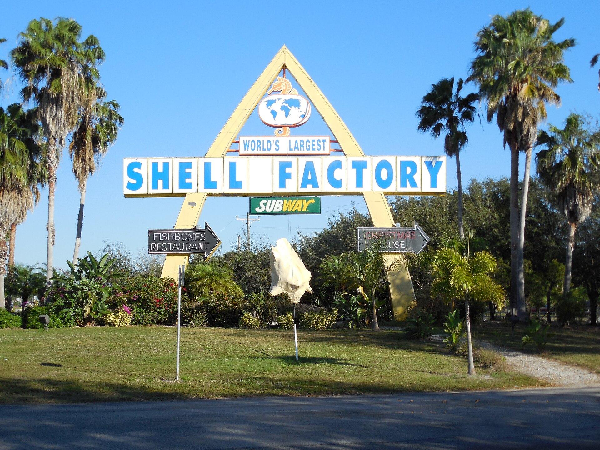
North Fort Myers held at about 40,000 people through the 2000s while part of it was annexed by Cape Coral. Hurricane Ian badly damaged its mobile home parks in 2022, and the Shell Factory, closed in 2024, was sold for redevelopment in 2026.

Image shown for this era: The tall A-frame "World's Largest Shell Factory" roadside sign seen from U.S. 41 in North Fort Myers, framed by palm trees under a clear blue sky. 2013 · FreeSharer4, CC BY-SA 3.0, via Wikimedia Commons · CC BY-SA · Source

Key moments

  1. Hurricane Ian hits mobile home parks

    Residents returned after Hurricane Ian to find heavy damage to mobile homes in North Fort Myers.

    Source

    1. People assess mobile home damage in North Fort Myers, WGCU Public Media (accessed 2026-11-09)
  2. The Shell Factory closes

    After damage from Hurricane Ian, the Shell Factory and Nature Park closed, ending its run as a roadside attraction.

    Source

    1. Former Shell Factory property in North Fort Myers sold for $3.9 million, North Fort Myers Neighbor (accessed 2026-11-09)
  3. Shell Factory site sold

    The 19-acre former Shell Factory site between the two US 41s was sold for $3,925,000 to a buyer planning redevelopment.

    Source

    1. Former Shell Factory property in North Fort Myers sold for $3.9 million, North Fort Myers Neighbor (accessed 2026-11-09)
Correct this era: Storms and change on the old Trail

Then & Now

North Fort Myers, 1872 to 2026

Settlers found New Prospect · drag to compare

1940 census map of central Lee County showing the north shore of the Caloosahatchee opposite Fort Myers, with the New Prospect, Slater and Bay Shore precincts, the settlements of Salvista, Bayshore and Slater, and US 41 running north toward Punta Gorda.
The tall A-frame "World's Largest Shell Factory" roadside sign seen from U.S. 41 in North Fort Myers, framed by palm trees under a clear blue sky
18722026

Then image1940 · U.S. Census Bureau, 1940 Census Enumeration District Maps, Lee County (National Archives 5829693), via Wikimedia Commons · Public domain · Source

Now image2013 · FreeSharer4, CC BY-SA 3.0, via Wikimedia Commons · CC BY-SA · Source

Help us get it right

History is never finished.

This timeline is compiled from the public records cited on each era and event. Every quote is checked against its source automatically, and items marked Reviewed have also been checked by a person. Images are public domain or openly licensed, each with its credit. If you know something we’ve missed or got wrong, or you hold records of your own, we’d like to hear from you.

See what’s happening in North Fort Myers today →