Skip to content

Sanibel,through time.

6 eras · 1513–2026 · every fact sourced · compiled from the sources shown, not yet reviewed by a historian

Populationfrom 1990

—

Calusa Island and Spanish Florida

1513–1831: Calusa Island and Spanish Florida

Era 1 · 1513–1831

Calusa Island and Spanish Florida

For more than 2,000 years the Calusa made Sanibel their home, living off the sea. Ponce de Leon claimed Florida for Spain in 1513, and Spain ceded Florida to the United States in 1819.

Image shown for this era: Black-and-white detail of Bernard Romans's 1774 chart of the coast from Charlotte Harbor south to Bay Carlos (San Carlos Bay), showing Boca Gasparilla, Boca Captiva, the island chain including Sanibel, and soundings in the channels. 1774 · Bernard Romans, 1774; Library of Congress Geography and Map Division via Florida Educational Technology Clearinghouse (via Wikimedia Commons) · Public domain · Source

Sources

  1. About Us: J.N. "Ding" Darling National Wildlife Refuge, U.S. Fish and Wildlife Service (accessed 2026-11-09)
  2. Sanibel Island History collection, PALMM (Florida Virtual Campus), with the Sanibel Public Library and Sanibel Historical Village and Museum (accessed 2026-11-09)
Correct this era: Calusa Island and Spanish Florida

Era 2 · 1832–1925

Colony, Lighthouse and Homesteads

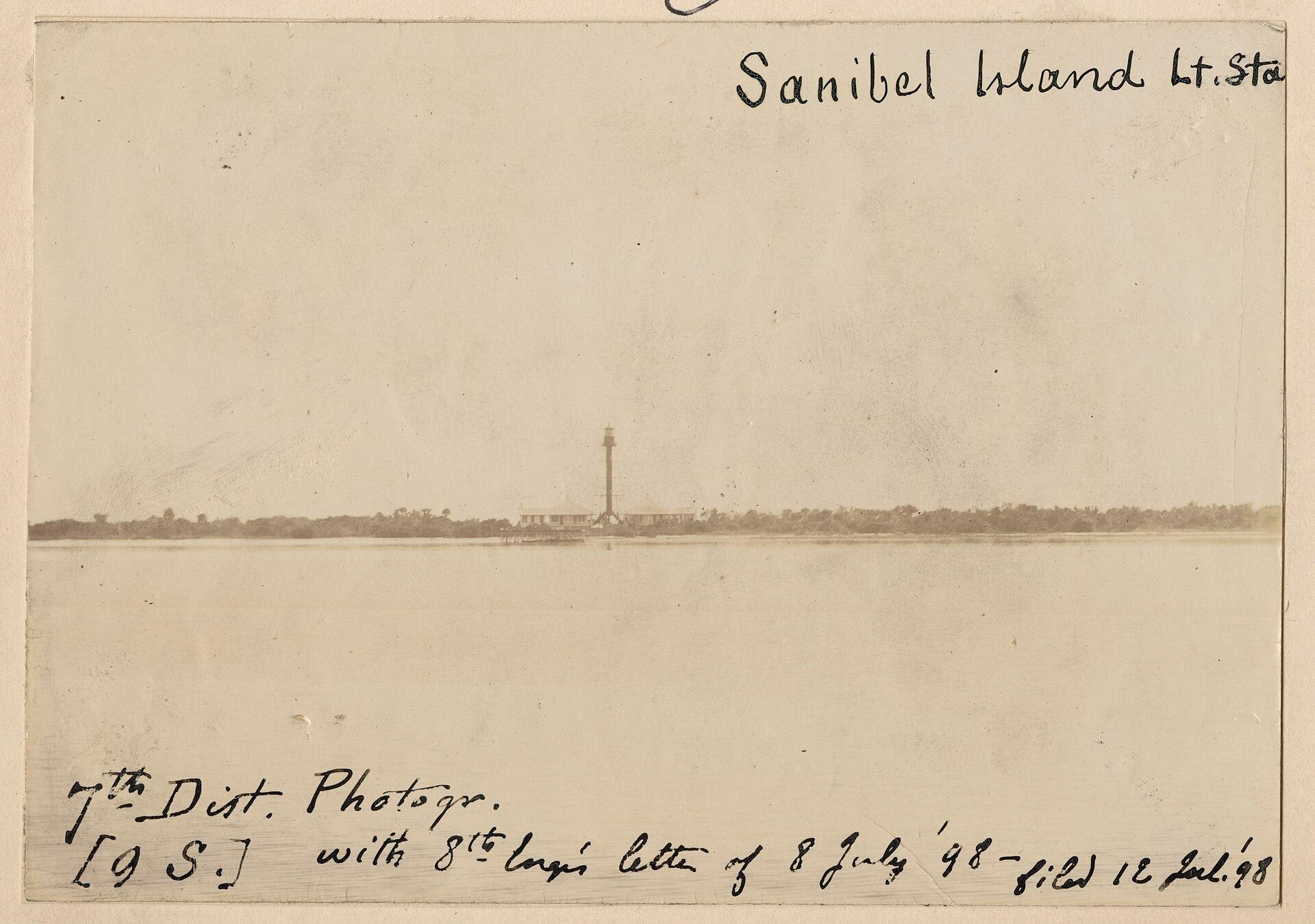
A short-lived colony of settlers from New York arrived in 1833. The Sanibel lighthouse was first lit in 1884, and by the early twentieth century the island supported farms growing avocado, citrus and eggplant.

Image shown for this era: Faded 1898 photograph of the Sanibel Island light station seen across calm water: a tall skeleton iron lighthouse tower between two raised keepers' houses on a low wooded shoreline, captioned by hand 'Sanibel Island Lt. Sta'. 1898 · U.S. Lighthouse Service, 7th District photographer, 1898; National Archives and Records Administration (via DPLA and Wikimedia Commons) · Public domain · Source

Key moments

  1. Settlers from New York found a colony

    A small group of settlers sent by the Florida Peninsular Land Company arrived from New York; within five years the island was nearly deserted again.

  2. Islanders petition for a lighthouse

    Thirteen Sanibel residents petitioned the U.S. Treasury Department for a lighthouse; the government showed no interest at the time.

  3. Sanibel lighthouse is first lit

    After the ship carrying its ironwork sank two miles offshore and most parts were salvaged, the Sanibel lighthouse was finished and lit for the first time.

1 more from this era
  1. Island school for white children is built

    Sanibel's school for white children was built at what is now Bailey Road and Periwinkle Way; it now stands at the Sanibel Historical Museum and Village.

    Source

    1. Historical Village houses first Sanibel school, Island Reporter (captivasanibel.com), by the Sanibel Historical Museum and Village (accessed 2026-11-09)

Sources

  1. National Register of Historic Places Nomination: Sanibel Lighthouse and Keepers' Quarters, National Park Service (accessed 2026-11-09)
  2. Sanibel Island History collection, PALMM (Florida Virtual Campus), with the Sanibel Public Library and Sanibel Historical Village and Museum (accessed 2026-11-09)
Correct this era: Colony, Lighthouse and Homesteads

Era 3 · 1926–1962

Storm, Ferry Days and the Refuge

A fierce hurricane in 1926 destroyed the island's farming. In 1945, at Ding Darling's urging, President Truman created the Sanibel National Wildlife Refuge; the island was still reached by ferry.

Image shown for this era: Black-and-white photograph from September 1947 of a raised lighthouse keeper's house on stilts at the Sanibel Island Light, with beach sand scoured away beneath it after the hurricane and palm trees beside it. 1947 · State Archives of Florida, Florida Memory (via Wikimedia Commons) · Public domain · Source

Key moments

  1. Hurricane ends island farming

    A fierce hurricane destroyed Sanibel's agriculture industry; until then the island had mainly been used by farmers.

    Source

    1. About Us: J.N. "Ding" Darling National Wildlife Refuge, U.S. Fish and Wildlife Service (accessed 2026-11-09)
  2. Sanibel National Wildlife Refuge is created

    At the urging of conservationist Jay Norwood "Ding" Darling, President Harry S. Truman signed an executive order creating the Sanibel National Wildlife Refuge.

    Source

    1. About Us: J.N. "Ding" Darling National Wildlife Refuge, U.S. Fish and Wildlife Service (accessed 2026-11-09)

Sources

  1. About Us: J.N. "Ding" Darling National Wildlife Refuge, U.S. Fish and Wildlife Service (accessed 2026-11-09)
  2. About Us: J.N. "Ding" Darling National Wildlife Refuge, U.S. Fish and Wildlife Service (accessed 2026-11-09)
Correct this era: Storm, Ferry Days and the Refuge

Era 4 · 1963–1974

Causeway and Home Rule

The 1963 causeway replaced the ferry and opened the island to tourism and development. By 1973 about 2,300 residents lived on Sanibel, and amid intense development islanders pursued home rule.

Image shown for this era: Black-and-white photograph of the long, low concrete span of the original Sanibel Causeway stretching across the bay, with small waves washing over a seawall in the foreground. 1969 · State Archives of Florida, Florida Memory (via Wikimedia Commons) · Public domain · Source

Key moments

  1. Causeway replaces the ferry

    A causeway with a drawbridge replaced the ferry to Sanibel, opening the island to tourism and development.

    Source

    1. Sanibel & Captiva Chamber of Commerce History, Sanibel & Captiva Islands Chamber of Commerce (accessed 2026-11-09)
  2. Sanibel's integrated school opens

    Black and white parents petitioned to desegregate the new island school, which became the first integrated school in Lee County; the old school for white children was vacated when it opened.

    Source

    1. Historical Village houses first Sanibel school, Island Reporter (captivasanibel.com), by the Sanibel Historical Museum and Village (accessed 2026-11-09)
  3. Refuge renamed for Ding Darling

    The national wildlife refuge on Sanibel was renamed in honor of conservationist Jay Norwood "Ding" Darling.

    Source

    1. About Us: J.N. "Ding" Darling National Wildlife Refuge, U.S. Fish and Wildlife Service (accessed 2026-11-09)
2 more from this era
  1. Sanibel-Captiva Conservation Foundation is incorporated

    Growing out of the Ding Darling memorial effort, SCCF was incorporated to preserve Sanibel's interior freshwater wetlands; it became the island's largest private landowner.

    Source

    1. Sanibel's 50th Anniversary, Sanibel-Captiva Conservation Foundation (accessed 2026-11-09)
  2. Sanibel votes to become a city

    On November 5, 1974, almost 85 percent of Sanibel's registered voters turned out and approved incorporation, 63.6 percent to 36.3 percent, after a fight with Lee County over how densely the island would be developed.

    Source

    1. Sanibel's success as a city credited to incorporation, Island Reporter (captivasanibel.com) (accessed 2026-11-09)

Sources

  1. Sanibel & Captiva Chamber of Commerce History, Sanibel & Captiva Islands Chamber of Commerce (accessed 2026-11-09)
  2. Sanibel's 50th Anniversary, Sanibel-Captiva Conservation Foundation (accessed 2026-11-09)
Correct this era: Causeway and Home Rule

Era 5 · 1975–2021

A Sanctuary City

The new city built its land-use plan on the 1976 Sanibel Report, an environment-based study funded by the Sanibel-Captiva Conservation Foundation. About 70 percent of the island is now protected conservation land.

Image shown for this era: White pelicans, egrets and a cormorant silhouetted on a mudflat in golden sunset water at the J.N. "Ding" Darling National Wildlife Refuge. 2013 · George Gentry / U.S. Fish and Wildlife Service (via Wikimedia Commons) · Public domain · Source

Key moments

  1. The Sanibel Report shapes the city's land-use plan

    SCCF funded the Sanibel Report, a study of the island's natural systems that became the basis of the city's comprehensive land use plan.

    Source

    1. History, Sanibel-Captiva Conservation Foundation (accessed 2026-11-09)
  2. Hurricane Charley's surge reaches the island

    During Hurricane Charley, observers estimated storm surges of 6 to 7 feet on Sanibel and Estero islands.

    Source

    1. Tropical Cyclone Report: Hurricane Charley, NOAA National Hurricane Center (accessed 2026-11-09)

Sources

  1. History, Sanibel-Captiva Conservation Foundation (accessed 2026-11-09)
  2. History, Sanibel-Captiva Conservation Foundation (accessed 2026-11-09)
Correct this era: A Sanctuary City

Era 6 · 2022–2026

Hurricane Ian and the Rebuild

Hurricane Ian's storm surge reached 9 to 13 feet above ground on eastern Sanibel in 2022 and cut the causeway. The city marked its 50th anniversary in 2024 while hotels and businesses were still being rebuilt.

Image shown for this era: A tall yellow crane works beside the repaired Sanibel Causeway roadway on November 14, 2022, as a pickup truck drives across toward the island under a clear sky. 2022 · Jocelyn Augustino/FEMA (via DVIDS) · Public domain · Source

Key moments

  1. Hurricane Ian floods eastern Sanibel

    Hurricane Ian's surge reached 9 to 13 feet above ground on the eastern part of Sanibel, and a USGS sensor on the island measured 12.58 feet above high water.

    Source

    1. Tropical Cyclone Report: Hurricane Ian, NOAA National Hurricane Center (accessed 2026-11-09)
  2. Causeway reopens three weeks after Ian

    The Sanibel Causeway, broken in several places by Hurricane Ian, reopened with temporary repairs and residents and business owners could drive back onto the island.

  3. City marks its 50th anniversary

    Sanibel opened its 1983 time capsule at City Hall to begin a 13-month celebration of its 1974 incorporation, while the island was still recovering from Ian.

    Source

    1. City of Sanibel celebrating golden anniversary, Santiva Chronicle (accessed 2026-11-09)

Sources

  1. Tropical Cyclone Report: Hurricane Ian, NOAA National Hurricane Center (accessed 2026-11-09)
  2. City of Sanibel celebrating golden anniversary, Santiva Chronicle (accessed 2026-11-09)
Correct this era: Hurricane Ian and the Rebuild

Then & Now

Sanibel, 1974 to 2026

Sanibel votes to become a city · drag to compare

Faded 1898 photograph of the Sanibel Island light station seen across calm water: a tall skeleton iron lighthouse tower between two raised keepers' houses on a low wooded shoreline, captioned by hand 'Sanibel Island Lt. Sta'
The brown iron Sanibel lighthouse and its two white keepers' cottages behind sea grape trees, with beachgoers on the white sand and blue water in the foreground under a clear sky
19742026

Then image1898 · U.S. Lighthouse Service, 7th District photographer, 1898; National Archives and Records Administration (via DPLA and Wikimedia Commons) · Public domain · Source

Now image2019 · Pete Markham, CC BY-SA 2.0, via Wikimedia Commons · CC BY-SA · Source

Help us get it right

History is never finished.

This timeline is compiled from the public records cited on each era and event. Every quote is checked against its source automatically, and items marked Reviewed have also been checked by a person. Images are public domain or openly licensed, each with its credit. If you know something we’ve missed or got wrong, or you hold records of your own, we’d like to hear from you.

See what’s happening in Sanibel today →